18 April 2020
This Eltham Activity Structure Plan Review follows the Council Plan 2017 -21 decision to, “Review ….to encourage investment and development’.
The most commonly received response received from residents in the 2018 public consultation survey on the Activity Centre involved the need to ‘better reflect ‘Eltham’s heritage and unique landscape setting’.
Please read the Draft Structure Plan, particularly the VISION STATEMENT and provide feedback to council by 11.59pm on April 29th. https://participate.nillumbik.vic.gov.au/eltham
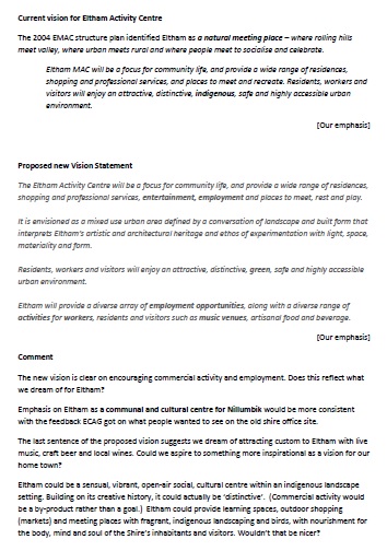
Vision Statement
Does Council’s proposed Vision for Eltham for the next ten years gel with yours?
We really have to ask ourselves if what Council is proposing is what we want to see happen on our town?
Click here to see the 2004 vision for Eltham to compare it to the proposed 2020 vision
ECAG had planned to invite council staff to explain the draft to residents at a combined AGM/information evening in April but unfortunately with COVID19 restrictions that is now impossible. Paul Fyffe, Nillumbik Council Chief Strategic Planner, is however, very willing to answer your questions. 9433 3218.
The Draft Plan
There is much in the plan to be recommended such as its stated aim ‘to maintain and reflect in the activity centre the Eltham character, architecture, landscape, vegetation.‘
However ECAG is only too aware that the devil is in the detail and that developers look for any loophole in a policy. Council policies must be tightly and unambiguously worded to prevent VCAT from agreeing with a developer that, for example, if Council really meant X, then they should have been more specific in their policy.
Some of our comments below relate to that. Others are points we consider important and that you may consider worthwhile including in a response to council.
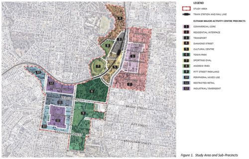
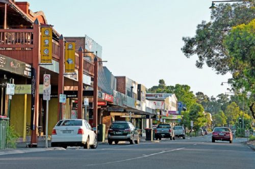
The plan discusses the various issues as they apply to the activity centre in general and then as relevant to specific Precincts (areas in Eltham) as shown in the map below.
1.Buildings will be required to be set back 5.5 m from the PROPERTY BOUNDARY in Precinct 2 Residential Interface. This is an important and very welcome change as previously it was 5.5m from the kerb which could and did allow developments to be built almost on the property boundary.
2.Green/leafy/trees/vegetation/canopy/landscape
These are mentioned many times throughout the plan which is excellent.
However there are very few times within the whole document where the term ‘native’ is used and only one or two where ‘indigenous’ or ‘non indigenous native’ is used.
In other words our current indigenous or non indigenous native tree canopy, which is the Eltham Character, could be completely removed and replaced by exotics.
Council itself has been seen not to follow the Council document ‘Live Local & Plan Local’. The term ‘native’ covers vegetation from anywhere in Australia and some native plants/trees are now termed environmental weeds in Nillumbik.
3. Building heights and densities. On the whole these remain the same, although along Main Road as far south as the former CFA building, the maximum number of storeys would be 5 (up from 4) and in some parts 4 (up from 3).
4. Traffic movement and parking
Replacing the Luck/Main roundabout with signals, signalizing Arthur/Main intersection, maybe removing existing pedestrian crossing opposite Eltham Arcade are suggested options.
That would be 4 sets of lights between Dudley and Pryor!
Extra lights may calm traffic on Main Rd but would likely increase ‘rat running’ on Bible St. Suggestions for minimizing ‘rat running’ include: replacing school crossing with a raised pedestrian crossing, improving intersection treatments at Arthur and Pryor, 2 hour parking restrictions.
5. Commuter Parking
‘Investigate implementing an additional 200 car spaces adjacent to the train station and 200 car spaces adjacent to the library’ is suggested.
Also ‘Carparking should be decked into the building or sleeved with other uses’. Which building? Does this mean to the old Shire Office site??
While commuter parking is no doubt an issue exactly what and where is meant here needs clarification.
Key issues in individual precincts include:
Precinct 1 Commercial Core
- Encourage an employment anchor eg involving education, health or public administration Where would this be we wonder?
- Traffic calming measures in Main Road described above and more pedestrian friendly side streets eg Commercial Place
- Flat or modest pitch roof lines
- 5 storey maximum
- Materials and colours to blend with the natural environment. NB However what colours or materials would ‘blend’ would be up to whose interpretation?
Precinct 2 Residential Interface
- Setbacks have been increased – 5.5 m landscaped front setback from the property boundary, 4m side setback to allow for small more slender trees
- 7m rear setback to respond to the existing backyard character
- 3 storey maximum (4 storeys along Circulatory Rd)
NB the map on page 24 has Precinct 2 marked as Medium-High Density which is definitely higher than 3 storeys, contradicting other statements in this document.
Precinct 3 Transport
- Encourage development between Main Road and Youth Road
- ‘Investigate implementation of an additional 200 commuter car spaces adjacent to the train station.’ “decked or sleeved’
Precinct 4 Diamond Street
- ‘Retain its aged care function and subject to flooding constraints…densify to respond to the aging population..’ but in what way – up?
Precinct 5 Cultural Centre
This extends from the library to the station and across to the southern part of Youth Rd.
The many options suggested can be read as mainly relating to the former shire office site and the War Memorial complex land:
- A major employment anchor eg health (Community Hospital), education (?), public administration (Shire Offices)
- Regional Art Gallery,
- Multi Purpose Community Hub,
- Residential,
- Professional offices
- Pop up parks, playgrounds, cinema
Whatever is built will be encouraged to be an ‘iconic’, landmark building
The last time the word iconic was used by a Council we got the Blockbuster building(now bottleshop/gym) at the railway crossing!!

The War Memorial and Old Shire Office Site land should have ‘generous landscaped setbacks’, built form should be ‘stepped down’ from Main Road, however there are no specific measurements. While it appears there should be a 3 metre setback on boundaries facing the public realm there is no detail regarding site coverage.
It would appear that this precinct could become a massive development!
‘Development should recognize heritage elements within the precinct.’
Does that mean the Eltham library which has a Heritage Overlay? Or a plaque saying ‘This was the site of Eltham Shire Offices’ ? or ‘War Memorial buildings were here’?
Precinct 6 Town Park
Precinct 7 Sporting Oval
Precinct 8 Andrew Park
Precinct 9 Pitt St Parkland
Precinct 10 Peripheral Mixed Use
Encourage limited retail and food venues, health centres, offices, recreation
Precinct 11 Restricted Retail
‘Recognise and improve Bridge St as a significant Gateway to Eltham.’
The use of ‘Gateway’ is of concern as its use could lessen the importance of our historically and environmentally iconic Eltham Gateway.
Precinct 12 Industrial/Emergent